
Vancouver, British Columbia--(Newsfile Corp. - November 18, 2025) - Intrepid Metals Corp. (TSXV: INTR) (OTCQB: IMTCF) ("Intrepid" or the "Company") is pleased to provide assay results from two additional diamond drill holes from the Ringo Zone, part of the ongoing 2025 drill campaign at the Company's flagship Corral Copper Property ("Corral" or the "Property") in Cochise County, Arizona (see Figures 1 and 2 below).
Although the Company continues to intersect copper-gold-silver mineralization that is consistent with carbonate replacement ("CRD") systems, Intrepid has identified multiple converging geological features that demonstrate the presence of one or more porphyry centers adjacent to current drilling (see Photos 1 - 3 below). The Company has identified:
- Widespread quartz-sericite-pyrite ("QSP") alteration, including porphyry D-veins which form a "halo" surrounding porphyry deposits
- Angular chalcopyrite-molybdenite-bearing breccia clasts interpreted to have been transported from the mineralized core of a porphyry system
- Cross-cutting porphyry-style vein stockworks, consistent with the top or 'roof' of a porphyry system
Taken together, these features form a coherent geological picture that significantly elevates Intrepid's confidence in the potential for a porphyry discovery beneath the CRD footprint at Corral Copper.
"These results are pointing us toward something much larger at Corral," said Mark Morabito, Chairman and CEO of Intrepid Metals. "The alteration, the mineralized clasts, and the stockwork veins we're now seeing are precisely the indicators you expect when you're close to a porphyry center. Individually, each feature is consistent with porphyry proximity. Collectively, they indicate that we are vectoring toward the metal source for the entire Corral Copper system. This significantly elevates the discovery potential of the project as we prepare for the next phase."
Highlights from Holes CC25_043 and CC25_044
CC25_0432:
- 112.30 meters ("m") of 0.52% Copper ("Cu"), 0.15 grams per ton ("gpt") Gold ("Au") and 3.04 gpt Silver ("Ag") (0.59% Copper Equivalent ("CuEq")1) including,
- 21.00m of 1.77 % Cu, 0.15 gpt Au and 8.01 gpt Ag (1.70% CuEq1).
CC25_044:
- 228.30m of 0.25% Cu, 0.17 gpt Au and 1.49 gpt Ag (0.36% CuEq1) including,
- 34.00m of 0.53% Cu, 0.47 gpt Au and 2.33 gpt Ag (0.75% CuEq1).
Evidence for Nearby Porphyry Deposit
Carbonate replacement ("CRD") style copper-gold-silver-zinc mineralization is the dominant form of mineralization identified to date at Corral. However, Intrepid's technical team has recognized porphyry-style alteration and mineralization that strongly support the presence of a porphyry system in close proximity to the Company's current drilling.
Widespread QSP (phyllic) alteration has been mapped across the target area (Photo 1). This style of alteration commonly forms a halo around the core of porphyry deposits and suggests that a hotter, mineral-rich potassic core (the part of the system that typically hosts the bulk of the copper and gold) is likely nearby.
In addition, Intrepid's technical team have identified breccia clasts containing chalcopyrite and molybdenite, minerals that originate the mineralized core of porphyry deposits (Photo 2). The angular geometry of these clasts suggests a short transport distance, indicating they were ripped from a nearby porphyry source, likely within reach of diamond drilling.
Shallow porphyry-style vein stockworks cross-cut white-mica-altered host rocks (Photo 3). These vein networks are consistent with the upper levels of porphyry systems and commonly occur directly above and/or adjacent to the mineralized core.
Taken together, these indicators provide multiple independent lines of evidence that the Corral Copper Property has potential for previously unrecognized bulk-tonnage porphyry copper-gold deposits and that the widespread CRD style mineralization identified to date can be leveraged to vector toward this style of mineralization.
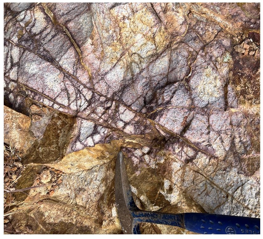
Photo 1: Widespread QSP and oxidized D veins and quartz veinlet stockworks.
Extensive QSP consistent with a phyllic halo around porphyry systems.
To view an enhanced version of this graphic, please visit:
https://images.newsfilecorp.com/files/6187/274871_intrepid1.jpg
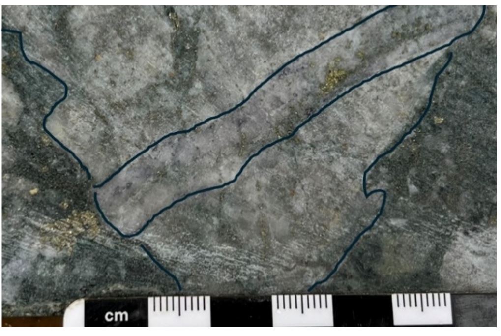
Photo 2: Breccia clasts with chalcopyrite – molybdenite B-veins.
Clasts containing chalcopyrite and molybdenite bearing quartz veins (minerals typically formed deep inside a porphyry system) suggesting that pieces of the porphyry core were broken off and transported. Angular nature of clasts suggests a short transport distance, suggesting that the porphyry center is within reach of current drilling.
To view an enhanced version of this graphic, please visit:
https://images.newsfilecorp.com/files/6187/274871_intrepid2.jpg
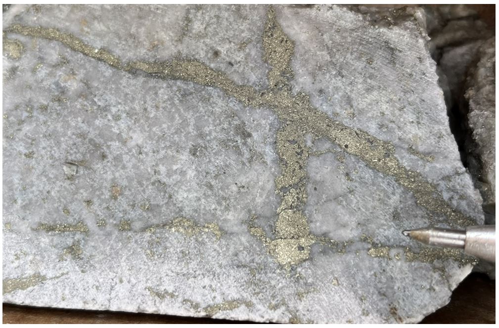
Photo 3: Widespread shallow porphyry-style veins stockworks.
Cross-cutting porphyry-style veins demonstrate the fluid flow pathways that fed the system. This geometry and intensity can occur in close spatial association with a porphyry core or center.
To view an enhanced version of this graphic, please visit:
https://images.newsfilecorp.com/files/6187/274871_intrepid3.jpg
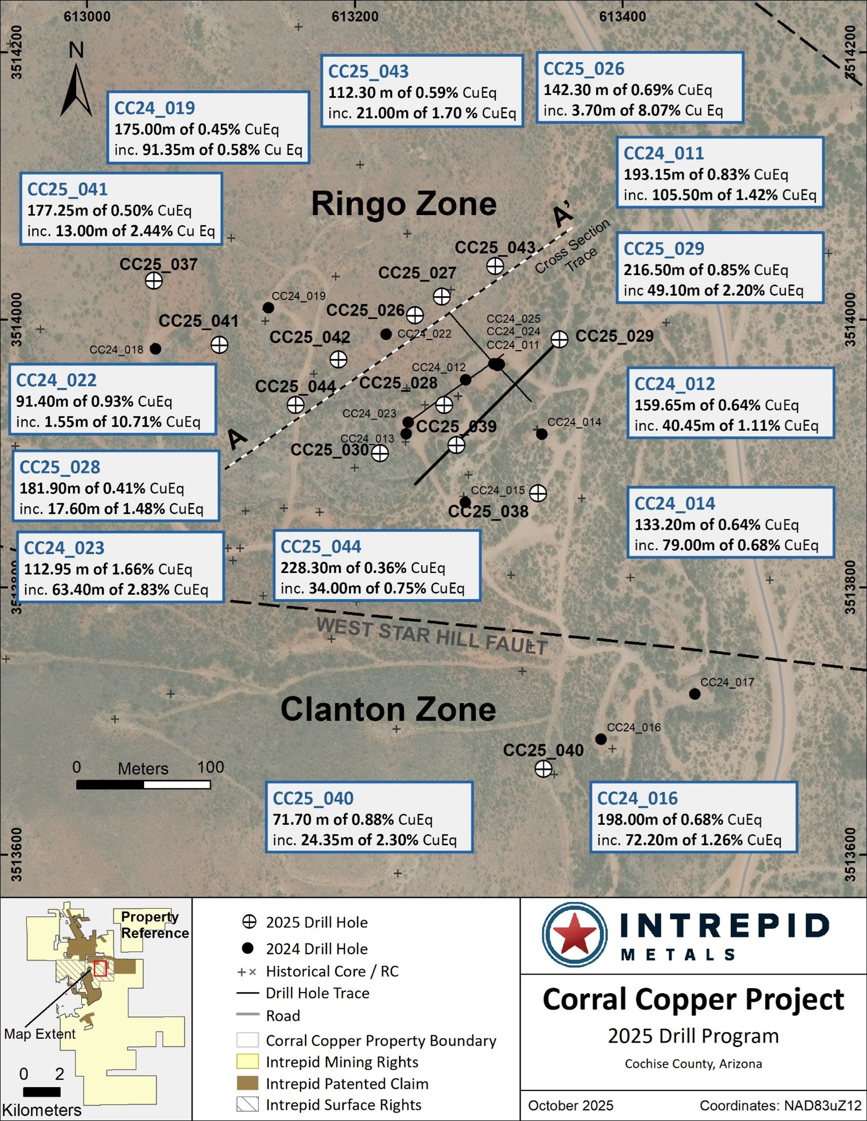
Figure 1: Drill plan map from the Ringo Zone at Corral Copper.
To view an enhanced version of this graphic, please visit:
https://images.newsfilecorp.com/files/6187/274871_abb59a5664190945_004full.jpg
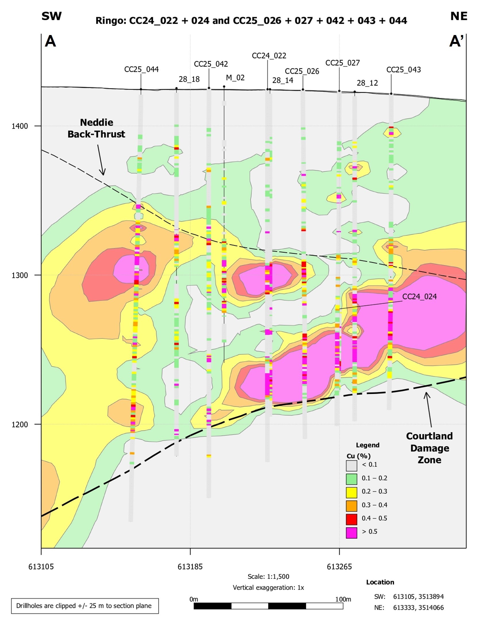
Figure 2: Cross Section through northern end of Ringo Zone3.
To view an enhanced version of this graphic, please visit:
https://images.newsfilecorp.com/files/6187/274871_abb59a5664190945_005full.jpg
Table 1: Drill Intercepts for the Ringo Zone1.
| CC25_038 & CC25_039 COMPOSITE INTERCEPTS | |||||||||
| DRILL HOLE DETAILS | ANALYZED GRADE | DILUTED METAL EQUIVALENT1 | |||||||
| DRILL HOLE | FROM | TO | LENGTH | COPPER | GOLD | SILVER | ZINC | CUEQ | AUEQ |
| ID | (m) | (m) | (m) | (%) | (ppm) | (ppm) | (%) | (%) | (ppm) |
| CC25_043 | 19.90 | 82.50 | 62.60 | 0.12 | 0.04 | 0.55 | 0.00 | 0.13 | 0.18 |
| INCL. | 21.00 | 29.00 | 8.00 | 0.32 | 0.06 | 1.68 | 0.00 | 0.33 | 0.45 |
| CC25_0432 | 84.60 | 196.90 | 112.30 | 0.52 | 0.15 | 3.04 | 0.10 | 0.59 | 0.81 |
| INCL. | 96.00 | 179.00 | 83.00 | 0.67 | 0.18 | 3.49 | 0.13 | 0.74 | 1.02 |
| AND | 144.50 | 165.50 | 21.00 | 1.77 | 0.15 | 8.01 | 0.08 | 1.70 | 2.34 |
| AND | 147.00 | 159.50 | 12.50 | 2.59 | 0.21 | 11.69 | 0.08 | 2.47 | 3.39 |
| CC25_043 | 207.65 | 208.95 | 1.30 | 0.10 | 0.07 | 1.60 | 0.08 | 0.16 | 0.22 |
| CC25_044 | 9.50 | 10.50 | 1.00 | 0.00 | 0.44 | 0.90 | 0.00 | 0.27 | 0.37 |
| CC25_044 | 27.50 | 255.80 | 228.30 | 0.25 | 0.17 | 1.49 | 0.12 | 0.36 | 0.49 |
| INCL. | 45.75 | 248.55 | 202.80 | 0.28 | 0.19 | 1.58 | 0.13 | 0.39 | 0.54 |
| AND | 77.35 | 143.00 | 65.65 | 0.44 | 0.37 | 1.72 | 0.15 | 0.65 | 0.89 |
| AND | 109.00 | 143.00 | 34.00 | 0.53 | 0.47 | 2.33 | 0.00 | 0.75 | 1.03 |
Table 2: Drill Hole Location Information for all holes drilled in 2025.
| DRILL HOLE | START DATE | END DATE | EASTING (m) | NORTHING (m) | ELEVATION (m) | AZIMUTH (°) | INCLINATION (°) | DEPTH (m) |
| CC25_026 | 2025-04-28 | 2025-05-03 | 613245 | 3514003 | 1424 | 0 | -90 | 234.4 |
| CC25_027 | 2025-05-04 | 2025-05-08 | 613265 | 3514017 | 1423 | 0 | -90 | 224.65 |
| CC25_028 | 2025-05-09 | 2025-05-16 | 613267 | 3513936 | 1420 | 0 | -90 | 240.8 |
| CC25_029 | 2025-05-17 | 2025-05-23 | 613353 | 3513985 | 1415 | 225 | -60 | 305.1 |
| CC25_030 | 2025-05-24 | 2025-05-30 | 613219 | 3513900 | 1423 | 0 | -90 | 270.7 |
| CC25_031 | 2025-05-31 | 2025-06-06 | 611891 | 3515918 | 1501 | 235 | -40 | 320.65 |
| CC25_032 | 2025-06-07 | 2025-06-12 | 612028 | 3515934 | 1472 | 0 | -90 | 313.05 |
| CC25_033 | 2025-06-12 | 2025-06-17 | 612135 | 3515757 | 1485 | 235 | -80 | 230.1 |
| CC25_034 | 2025-06-18 | 2025-06-22 | 612169 | 3514840 | 1495 | 250 | -45 | 204.2 |
| CC25_035 | 2025-06-22 | 2025-06-29 | 612258 | 3514776 | 1494 | 245 | -50 | 249.95 |
| CC25_036 | 2025-06-30 | 2025-07-06 | 612177 | 3514898 | 1497 | 250 | -50 | 219.6 |
| CC25_037 | 2025-07-07 | 2025-07-18 | 613050 | 3514029 | 1435 | 0 | -90 | 334.65 |
| CC25_038 | 2025-07-19 | 2025-07-29 | 613337 | 3513870 | 1422 | 0 | -90 | 282.55 |
| CC25_039 | 2025-07-30 | 2025-08-09 | 613276 | 3513906 | 1420 | 0 | -90 | 255.75 |
| CC25_040 | 2025-08-10 | 2025-08-22 | 613341 | 3513664 | 1438 | 0 | -90 | 331.30 |
| CC25_041 | 2025-08-23 | 2025-08-27 | 613099 | 3513981 | 1428 | 0 | -90 | 310.00 |
| CC25_042 | 2025-08-28 | 2025-09-02 | 613188 | 3513970 | 1425 | 0 | -90 | 274.90 |
| CC25_043 | 2025-09-03 | 2025-09-10 | 613305 | 3514040 | 1420 | 0 | -90 | 212.15 |
| CC25_044 | 2025-09-11 | 2025-09-15 | 613156 | 3513936 | 1425 | 0 | -90 | 290.15 |
| CC25_045 | 2025-09-15 | 2025-09-22 | 614067 | 3513972 | 1411 | 215 | -70 | 391.05 |
| CC25_046 | 2025-09-23 | 2025-09-27 | 613206 | 3513935 | 1423 | 0 | -90 | 269.75 |
Technical Information
All scientific and technical information in this news release has been reviewed and approved by Daniel MacNeil, P.Geo. Mr. MacNeil is a Technical Advisor to the Company and is a qualified person for the purposes of National Instrument 43-101 - Standards of Disclosure for Mineral Projects.
Mr. MacNeil has verified the drilling data disclosed in this news release, including the assay and test data underlying the information or opinions contained in this news release. Mr. MacNeil verified the data disclosed (including previously released Intrepid data underlying the information disclosed) in this news release by reviewing imported and sorted assay data; checking the performance of blank samples and certified reference materials; reviewing the variance in field duplicate results; and reviewing grade calculation formulas. Mr. MacNeil detected no significant QA/QC issues during review of the data and is not aware of any sampling, recovery or other factors that could materially affect the accuracy or reliability of the drilling data referred to in this news release.
As it relates to adjacent properties disclosed in this news release, Mr. MacNeil has been unable to verify the information and that the information is not necessarily indicative to the mineralization on the Corral Copper Property.
Quality Assurance and Quality Control
Drill core was first reviewed by a geologist, who identified and marked intervals for sampling. The marked sample intervals were then cut in half with a diamond saw; half of the core was left in the core box and the other half was removed, placed in plastic bags, sealed and labeled. Intervals and unique sample numbers are recorded on the drill logs and the samples are sequenced with standards and blanks inserted according to a predefined QA/QC procedure. The samples are maintained under security on site until they are shipped to the analytical lab.
All core samples were sent to ALS Geochemistry (ALS), a division of ALS Global, in Tucson, Arizona, for sample preparation, with pulps sent to the ALS Geochemistry laboratory in Reno, Nevada for analysis. ALS meets all requirements of International Standards ISO/IEC 17025:2017 and ISO 9001:2015 for analytical procedures and is independent of the Company. HQ size core was split and sampled over approximately two metre intervals. Samples were analyzed using: ALS's Fire Assay Fusion method (Au-AA23) with an AA finish for gold and by gravimetric finish (Au-GRA21) for samples assaying greater than 10 ppm (gpt) gold; by a 36-element four acid digest ICP-AES analysis (ME-ICP61) with additional analysis for High Grade Cu (Cu-OG62), High Grade Zn (Zn-OG62) and High Grade Pb (Pb-OG62); and for silver assays above 100 ppm (g/t) by Fire Assay Fusion method with gravimetric finish (Ag-GRA21). ME-ICP61 results were reported in parts per million (ppm), High Grade (OG62) results were reported in percent (%). In addition to ALS quality assurance- quality control (QA/QC) protocols, Intrepid implements an internal QA/QC program that includes the insertion of sample blanks, duplicates, and standards, with QA QC control samples comprising approximately 10% of the sample stream.
About Corral Copper
The Corral Copper Property, located near historical mining areas, is an advanced exploration and development opportunity in Cochise County, Arizona. Corral is located 15 miles east of the famous mining town of Tombstone and 22 miles north of the historic Bisbee mining camp which has produced more than 8 billion pounds of copper4. Production from the Bisbee mining camp, or within the district as disclosed in the next paragraph, is not necessarily indicative of the mineral potential at Corral.
The district has a mining history dating back to the late 1800s, with several small mines extracting copper from the area in the early 1900s, producing several thousand tons. Between 1950 and 2008, various companies explored parts of the district, but the effort was uncoordinated, non-synergistic and focused on discrete land positions and commodities due to the fragmented ownership. There is over 50,000m of historical drilling at Corral mainly centered on the Ringo, Earp and Holliday Zones and although this core has been destroyed, Intrepid has a historical digital drill hole archive database which the Company uses for the purposes of exploration targeting and drill hole planning. Intrepid, through ongoing exploration drilling and surface geological mapping, sampling and prospecting is increasing confidence in the validity of this data.
Intrepid is confident that by combining modern exploration techniques with historical data and with a clear focus on responsible development, the Corral Copper Property can quickly become an advanced exploration stage project and move towards development studies.
About Intrepid Metals Corp.
Intrepid Metals Corp. is a Canadian company focused on exploring for high-grade essential metals such as copper, silver, and zinc mineral projects in proximity to established mining jurisdictions in southeastern Arizona, USA. The Company has acquired or has agreements to acquire several drill ready projects, including the Corral Copper Project (a district scale advanced exploration and development opportunity with significant shallow historical drill results), the Tombstone South Project (within the historical Tombstone mining district with geological similarities to the Taylor Deposit, which was purchased for $1.3B in 20185, though mineralization at the Taylor Deposit is not necessarily indicative of the mineral potential at the Tombstone South Project) both of which are located in Cochise County, Arizona and the Mesa Well Project (located in the Laramide Copper Porphyry Belt in Arizona). Intrepid has assembled an exceptional team with considerable experience with exploration, developing, and permitting new projects within North America. Intrepid is traded on the TSX Venture Exchange (TSXV) under the symbol "INTR" and on the OTCQB Venture Market under the symbol "IMTCF". For more information, visit www.intrepidmetals.com.
INTREPID METALS CORP.
On behalf of the Company,
"Mark Morabito"
Chairman & CEO
For further information regarding this news release, please contact:
Mark Morabito, Chairman & CEO
604-681-8030
info@intrepidmetals.com
Notes
1 Composite intervals are calculated using length weighted averages based on a combination of lithological breaks and copper, gold, silver and zinc assay values according to a 0.10% CuEq (see below) cutoff and include a maximum of 10 meters of internal dilution. All intervals reported are down hole core lengths, and true thicknesses have yet to be determined. Mineral resource modeling is required before true thicknesses can be estimated. Analyzed Grade corresponds composite weighted ("composites") averages of laboratory analyses. Metal Equivalent assumes estimated recovery factors including 85% recovery for copper, and 80% recovery for gold, silver and zinc for reported composite intervals. Metal prices used for the CuEq and AuEq calculations are in USD based on Ag $37.00/oz, Au $3000/oz, Cu $3.80/lb, Zn $1.15/lb The following equation was used to calculate copper equivalence: CuEq = Copper (%) (85% rec.) + (Gold (g/t) x 0.71)(80% rec.) + (Silver (g/t) x 0.0077)(80% rec.) + (Zinc (%) x 0.28)(80% rec.). The following equation was used to calculate gold equivalence: AuEq = Gold (gpt)(80% rec.) + (Copper (%) x 1.4085)(85% rec.) + (Silver (gpt) x 0.0108)(80% rec.) + (Zinc (%) x 0.4188)(80% rec.). Analyzed metal equivalent calculations are reported for illustrative purposes only. The metal chosen for reporting on an equivalent basis is the one that contributes the most dollar value after accounting for assumed recoveries.
2 Drill hole CC25_043 contains an interval where samples could not be obtained due to loss of recovery during drilling. This interval occurs from 122.55-123.45 (0.9m). This interval is located in a mineralized core run and has been included in composite calculations but has been assigned zero assay values for copper, gold, silver and zinc for purposes of weighted average composite intercept calculations.
3 Data disclosed in this news release includes historical drilling results and information derived from historic drill results, Intrepid has not undertaken any independent investigation of the sampling, nor has it independently analyzed the results of the historical exploration work in order to verify the results. Intrepid considers these historical data relevant as the Company is using this data as a guide to plan exploration programs. The Company's current and future exploration work includes verification of the historical data through drilling. Historical drill core assay data has been included in the Leapfrog numeric model to show the distribution of mineralization. The Copper numeric model was created using the Leapfrog® Radial Basis Function isotropic interpolant at 20m resolution with inputs from drill holes (Intrepid, 2024/2025) and historical drill hole information as well as surface rock sampling (Intrepid 2024/2025 and historical).
4 Information disclosed in this news release regarding the historic Bisbee Camp can be found on the Copper Queen Mine website, on the City of Bisbee website (www.bisbeeaz.gov/2174/Bisbee-History) and from Briggs, D.F., 2015, History of the Warren (Bisbee) Mining District, Arizona Geological Survey Contributed Report CR-15-b, 8 p.
5 Details regarding the sale of the Taylor Deposit can be found in South32 News Release dated October 8, 2018 (South32 completes acquisition of Arizona Mining).
Cautionary Note Regarding Forward-Looking Information
Certain statements contained in this release constitute forward-looking information within the meaning of applicable Canadian securities laws. Such forward-looking statements relate to: the potential of the property; the interpretation of drills results; potential of Corral as an emerging copper asset in a highly prospective district; advancing the geological understanding of Corral; the potential for a porphyry discovery; the discovery potential of Corral; potential for previously unrecognized bulk-tonnage porphyry copper-gold discoveries close by; he exploration potential of the Corral Copper Property and the Company's other mineral projects; and potential future production.
In certain cases, forward-looking information can be identified by the use of words such as "plans", "expects", "budget", "scheduled", "estimates", "forecasts", "intends", "anticipates" or "believes", or variations of such words and phrases or state that certain actions, events or results "may", "could", "would", "might", "occur" or "be achieved" suggesting future outcomes, or other expectations, beliefs, plans, objectives, assumptions, intentions or statements about future events or performance. Forward-looking information contained in this news release is based on certain factors and assumptions regarding, among other things, the Company can raise additional financing to continue operations; the results of exploration activities, commodity prices, the timing and amount of future exploration and development expenditures, the availability of labour and materials, receipt of and compliance with necessary regulatory approvals and permits, the estimation of insurance coverage, and assumptions with respect to currency fluctuations, environmental risks, title disputes or claims, and other similar matters. While the Company considers these assumptions to be reasonable based on information currently available to it, they may prove to be incorrect.
Forward-looking information involves known and unknown risks, uncertainties and other factors which may cause the actual results, performance or achievements of the Company to be materially different from any future results, performance or achievements expressed or implied by the forward-looking information. Such factors include risks inherent in the exploration and development of mineral deposits, including risks relating to the ability to access infrastructure, risks relating to the failure to access financing, risks relating to changes in commodity prices, risk related to unanticipated geological or structural formations and characteristics risks related to current global financial conditions, risks related to current global financial conditions and the impact of any future global pandemic on the Company's business, reliance on key personnel, operational risks inherent in the conduct of exploration and development activities, including the risk of accidents, labour disputes and cave-ins, regulatory risks including the risk that permits may not be obtained in a timely fashion or at all, financing, capitalization and liquidity risks, risks related to disputes concerning property titles and interests, environmental risks and the additional risks identified in the "Risk Factors" section of the Company's reports and filings with applicable Canadian securities regulators.
Although the Company has attempted to identify important factors that could cause actual actions, events or results to differ materially from those described in forward-looking information, there may be other factors that cause actions, events or results not to be as anticipated, estimated or intended. Accordingly, readers should not place undue reliance on forward-looking information. The forward-looking information is made as of the date of this news release. Except as required by applicable securities laws, the Company does not undertake any obligation to publicly update or revise any forward-looking information.
Neither the TSX Venture Exchange nor its Regulation Services Provider (as that term is defined in the policies of the TSX Venture Exchange) has reviewed or accepts responsibility for the adequacy or accuracy of this release.
![]()
To view the source version of this press release, please visit https://www.newsfilecorp.com/release/274871